
GPS improved by Galileo
Concerns about the accuracy and interference with the GPS signal are a source of worry for many navigators. Perhaps there is light at the end of the tunnel. The European Galileo programme has been testing the possibilities.
On 16 September, Galileo reached a significant milestone in the resilience of satellite navigation by demonstrating the very first civilian GNSS position that was authenticated using both navigation data and ranging measurements. The demonstration utilised the concept of the Galileo Signal Authentication Service (SAS), in which five Galileo satellites transmitted encrypted signal components across Europe. Receivers on the ground successfully processed these signals to calculate an authenticated position, thereby demonstrating a new level of protection for civil satellite navigation.
First authenticated position using Galileo satellites
On 16 September, between 14:00 and 16:00 UTC, five Galileo satellites – E06, E21, E23, E34 and E36 – encrypted one of their signal components, the E6-C signal at 1278.75 MHz, which is normally transmitted unencrypted. Several Galileo SAS receivers deployed at different locations successfully processed these signals in conjunction with the Galileo Open Service Navigation Message Authentication (OSNMA). For the first time, a civilian GNSS receiver was able to process authenticated navigation data and range measurements from at least four satellites simultaneously and calculate a precise position.
Spoofing in Norway
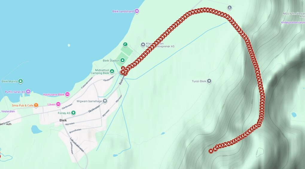
A significant part of the demonstration took place during the Jamming Test on the island of Andøya in Norway, where controlled GNSS jamming and spoofing tests are carried out using real signals transmitted over the air. This provided a unique opportunity to evaluate Galileo SAS under both nominal conditions and in the face of many types of spoofing. During the spoofing tests, conventional receivers were misled and reported false positions, whilst the Galileo SAS receiver detected the attack and maintained a reliable position determination based on authenticated Galileo signals.
Strengthening GNSS against spoofing

Explanation. Regarding the image above: Galileo SAS remains accurate during a spoofing test at Jammertest in Norway: the green dots on the left show the position determined by SAS, whilst the actual, correct position is maintained. The red markers show the spoofed positions of a commercial receiver. The spoofing signal forces the commercial receiver to calculate a false position. Image in the article: Three-dimensional representation of the same scenario. The spoofed trajectory starts at the actual position (at the bottom of the image), then jumps up towards the mountain, turns left and descends towards the city. The position is entirely determined by the spoofing device.
Spoofing is the transmission of falsified GNSS signals intended to mislead a receiver regarding its position or time. It poses a significant threat to satellite navigation, with incidents affecting sectors such as aviation and maritime transport. In the past, civilian GNSS receivers had limited means of verifying whether the signals they were using actually originated from navigation satellites. Galileo has addressed part of this vulnerability through OSNMA, which will be operational in 2025 and which verifies the navigation data transmitted by Galileo satellites. SAS complements OSNMA by protecting the other fundamental source of information used to calculate a GNSS position: the range measurements. “This demonstration marks a significant milestone for reliable satellite navigation. By combining the authentication of navigation messages with authenticated range measurements, Galileo strengthens resilience against spoofing and boosts confidence in the position information provided to users,” explained Guerric Pont, Head of PNT at EUSPA.
Galileo Signal Authentication Service
Galileo SAS enables civilian users to authenticate range signals without the need for receivers to be continuously assisted via a ground communication channel or to store secret cryptographic keys, as is typically required with traditional military-grade GNSS solutions. For each position determination, a SAS receiver records digital samples of the encrypted E6-C signal. A few seconds later, as soon as the corresponding Galileo OSNMA key has been broadcast via the signal in space, the receiver uses this, together with previously retrieved authenticationinformation to verify the recorded signal and calculate a position based on authenticated range measurements. Together, OSNMA and SAS provide complementary protection: OSNMA verifies the navigation message, whilst SAS verifies the range information. This combination enables receivers to detect and counter a wide range of spoofing attacks, thereby increasing confidence in the resulting positioning, navigation and timing (PNT) solution.
Source: European Union Agency for the Space Programme

Windassist sponsor